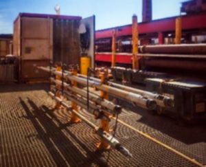
Fugro solutions include data acquisition services via our innovative equipment (WISON® Mk V downhole cone penetration test (CPT) system) that can be deployed from the base of the borehole which requires intrusive drilling methods via our specialized geotechnical drilling rigs mounted on owned or chartered vessels and/or via SEACALF MkIV & MkV DeepDrive CPT equipment which are deployed from the midship or stern of a vessel via a Launch and Recovery System and continuous in-situ CPT tests up to 55m below mud line could be acquired.
The WISON® Mk V downhole cone penetration test (CPT) system enables in situ soil properties to be measured from the base of a borehole.
- Driven by Fugro EcoDrive fluid, an eco-friendly alternative to traditional hydraulic oil
- Robust umbilical with reduced re-termination time
- High push force
- Improved constant speed
- Thrust capacity of 100 kN
- Down to 1000 m below drill floor
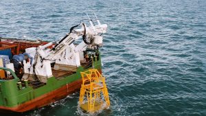
The SEACALF® MkIV is an innovative seabed deployed Cone Penetration Test (CPT) system, employing a coiled push rod and a compact continuous thrust machine.
- Fast deployable system which delivers high quality CPT data
- Coiled rod instead of manually assembled rod strings
- Compact and robust continuous drive system
- 200 kN push capacity and up to 55 m penetration length
The innovative SEACALF® MkV DeepDrive is an advanced seabed cone penetration test (CPT) system with enhanced soil penetration capacity. The system covers all features as the SEACALF® MkIV system and comes with additional advanced features such as the unique combination of a coiled rod and a friction reduction system that enables faster acquisition of deeper CPT’s from a wide range of vessels. The Continuous Drive System transfers the thrust force to the rod through its innovative dual clamp design. This eliminates slippage and ensures a constant 20 mm/sec penetration rate is maintained to acquire high quality data, even in variable soil conditions.
For more information on Fugro IOVTEC’s CPT solutions, please contact our team.
Borehole geophysical logging (BGL) services are critical to reducing the overall project risk of comprehensive marine site characterisation.
Advantages of Fugro IOVTEC’s BGL solutions include:
- Stackable downhole tools for multiple measurements in a single run
- High vertical resolution gives excellent definition to changes in the formation, down to a layer thickness of 5 cm
- Our borehole geophysical logging tools are heave compensated while measurements are being taken, resulting in more accurate and reliable results.
The data acquired by Fugro’s in-house BGL tools and experts can be integrated with other available Geo-datasets to optimise understanding of the subsurface, allowing meticulous assessment of the parameters of your offshore development project and facilitating cost-effective planning and design.
Enhancement of the site-specific ground model results in improved planning and design efficiency of the development site as well as lower operational costs.
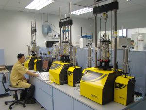
Our sophisticated testing programmes are crucial to projects with great sensitivity to soil behaviour. Our accredited soils laboratories use state-of-the-art equipment to perform testing to local and internationally accepted standards.
Our laboratory tests soils when the engineering properties of soil or rock influence the design of major structures or where ground risk is an important consideration. We provide a range of testing, from basic classification tests, through dynamic and cyclic tests on soils, to construction materials testing and quality assurance.
- Identify geohazards and engineering constraints
- Characterise geotechnical conditions across a site
- Identify data gaps and uncertainties
- Help develop site investigation recommendations
- Provide inputs to foundation assessments
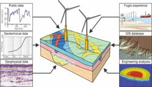
Site characterisation is an investigative process for understanding the geological and engineering conditions at a development site. It typically starts with a desk study generating an initial ground model that is refined in an evolutionary process normally involving progressive stages of data collection and analysis.
Ground modelling is the principal activity that enables geoscientists to carry out site characterisation efficiently. It is an effective way to integrate various site characterisation datasets, like terrain maps, geological and geotechnical samples, seismic profiles and soil parameters.
Our approach to ground modelling uses the best available data to design new data collection programmes and site investigations carefully, and to gain maximum value for money from expensive field programmes.
The ground model is a live, up-to-date state of knowledge of site conditions relevant to the development. It contains all available site characterisation data and analysis products. It is usually hosted in a geographical information system (GIS) to help with integration, analysis and providing outputs to client specifications – it also automatically enables efficient and secure retrieval and archiving.
Our ground models:
- Identify geohazards and engineering constraints
- Characterise geotechnical conditions across a site
- Identify data gaps and uncertainties
- Help develop site investigation recommendations
- Provide inputs to foundation assessments